

ScalLoc: Continuous Oblique Thermal UAV Geo-Localization with a 2D Satellite Map
Paper • 2610.14866 • Published
Thermal-Oblique is a dataset for continuous oblique thermal UAV geo-localization, introduced in the paper ScalLoc: Continuous Oblique Thermal UAV Geo-Localization with a 2D Satellite Map.
It supports research on Unmanned Aerial Vehicles (UAVs) operating in GNSS-denied environments, addressing the modality and viewpoint gaps between oblique thermal sequences and visible-light satellite imagery. The released resources support sequence-level localization using a geo-referenced 2D satellite map, without requiring a digital surface model (DSM) or a preconstructed 3D map.
Thermal-Oblique contains 216 complete trajectories and 28,112 thermal frames collected around Changsha, with frame-level position, height, and attitude annotations. It covers urban and rural environments, daytime and nighttime conditions, and three flight-path types: straight, curved, and orbiting.
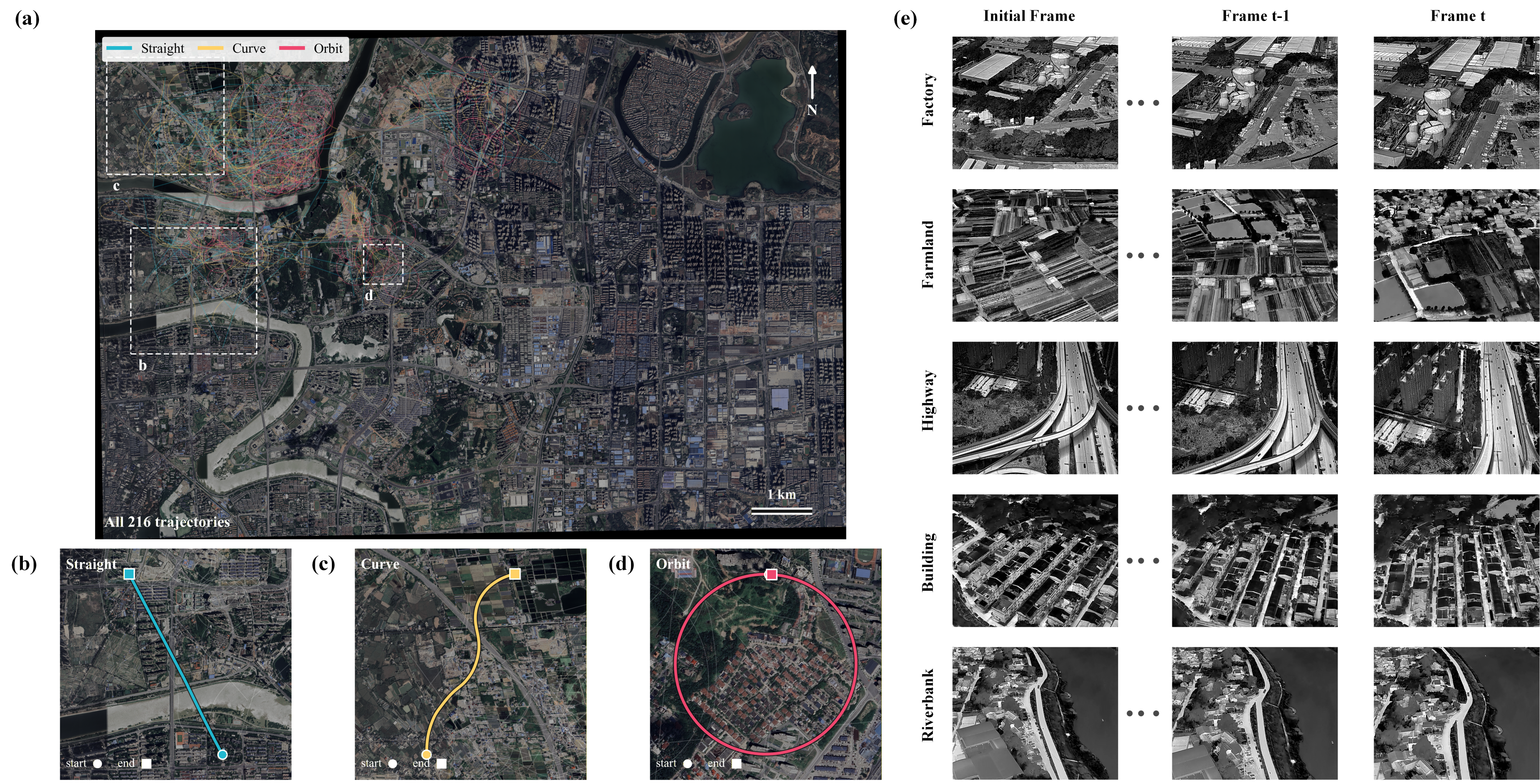
| Attribute | Coverage |
|---|---|
| Trajectories | 216 |
| Thermal frames | 28,112 |
| Environments | Urban: 108 trajectories; rural: 108 trajectories |
| Lighting conditions | Day: 108 trajectories; night: 108 trajectories |
| Flight paths | Straight: 72; curve: 72; orbit: 72 trajectories |
| Nominal relative-height settings | 150 m, 200 m, 250 m |
| Nominal downward pitch-angle magnitudes | 30°, 35°, 40° |
| Frame annotations | One Thermal_info.csv per trajectory |
| Satellite reference | Changsha map; 0.30 m/pixel; UTM zone 49N configuration |
Sequence names follow the pattern Scene_Time_Motion_H<height>_P<pitch>_S<index>, for example Rural_Day_Curve_H150_P30_S01. Height and pitch labels describe nominal acquisition settings; use the CSV values for frame-level measurements. In particular, P30 denotes a downward-angle magnitude, while recorded pitch values are negative in the example below.
All 216 trajectories are provided under test/changsha/, preserving the dataset's existing organization. This release does not define separate training, validation, and test partitions. The directory name is not a guarantee of geographic separation. When creating new splits, account for shared geographic coverage and disclose the split protocol.
The resource bundle also contains the satellite reference map and the three checkpoints used by the released ScalLoc configuration. These checkpoints are supporting resources, not dataset annotations. No DSM is included or required by the default pipeline.
Sign in to Hugging Face and accept the repository's access conditions if prompted. Access requests are currently approved automatically.
Archive SHA256:
218138569b6f22ee71d6c5bbb145fad645fce02491962651b983d11424eb7be1
Verify the checksum before extraction. Allow approximately 23.1 GB for the extracted resources in addition to the ZIP. Use a ZIP64-capable archive tool.
Extract the bundle into the ScalLoc repository root so that data/ and weights/ sit alongside run.py:
ScalLoc/
├── run.py                           # From the GitHub code repository
├── data/
│   ├── Thermal-Oblique/
│   │   └── test/
│   │       └── changsha/
│   │           ├── Rural_Day_Curve_H150_P30_S01/
│   │           │   ├── Thermal/
│   │           │   │   ├── Rural_Day_Curve_H150_P30_S01_T_f0000.JPG
│   │           │   │   ├── Rural_Day_Curve_H150_P30_S01_T_f0001.JPG
│   │           │   │   └── ...
│   │           │   └── Thermal_info.csv
│   │           └── <other sequences>/
│   │               ├── Thermal/
│   │               └── Thermal_info.csv
│   └── maps/
│       └── changsha/
│           └── ref.tif
├── weights/
│   ├── vggt/
│   │   └── model.safetensors
│   ├── minima/
│   │   └── minima_roma.pth
│   └── dinov2/
│       └── dinov2_vitl14_pretrain.pth
└── asset_bundle/
    ├── README.md
    ├── manifest.json
    ├── region_config_reference.yaml
    └── licenses/
Keep the original image filenames, image contents, CSV columns, and frame associations unchanged. Do not resize images or rewrite annotations when preparing the inputs. The map must be used with its matching geographic configuration in configs/regions/changsha.yaml.
Each trajectory has a CSV file named Thermal_info.csv. The following header and first row are from Rural_Day_Curve_H150_P30_S01:
num,filename,date,lat,lon,abs_height,rel_height,pitch,roll,yaw,TargetLatitude,TargetLongitude
1,Thermal/Rural_Day_Curve_H150_P30_S01_T_f0000.JPG,2026-07-13T18:32:47.651,28.276255,113.00257,175.769,150.153,-29.6,0.0,159.9,0.0,0.0
| Field | Description |
|---|---|
num |
Frame record index; the example begins at 1 |
filename |
Image path relative to the trajectory directory |
date |
Recorded timestamp; no timezone is encoded in this field |
lat, lon |
Recorded camera latitude and longitude, in degrees |
abs_height |
Recorded absolute height, in meters |
rel_height |
Recorded relative height, in meters |
pitch, roll, yaw |
Recorded camera attitude angles, in degrees |
TargetLatitude, TargetLongitude |
Retained target-coordinate fields; zero values, as in this example, must not be treated as valid ground-target annotations |
Preserve the original angle conventions and height references when reading the metadata. Camera intrinsics are configured in the ScalLoc code; they are not additional columns in these CSV files.
Follow the ScalLoc installation instructions, then check the resource paths:
python run.py --config configs/default.yaml --check
Run the default complete trajectory:
python run.py --config configs/default.yaml
The default trajectory is Rural_Day_Curve_H150_P30_S01. To evaluate all available trajectories:
python run.py --config configs/default.yaml --all-datasets
Resources can also remain on another disk: configure their external paths instead of copying them again. See the data and weights guide for placement instructions, configuration keys, and individual checkpoint hashes.
If you use Thermal-Oblique or ScalLoc in your research, please consider citing:
@article{zhang2026scalloc,
  title={ScalLoc: Continuous Oblique Thermal UAV Geo-Localization with a 2D Satellite Map},
  author={Zhang, Xiaoran and Liu, Yu and Liang, Jinyu and Xiao, Huaxin},
  journal={arXiv preprint arXiv:2610.14866},
  year={2026},
  url={https://arxiv.org/abs/2610.14866}
}
The author-provided Thermal-Oblique thermal images and annotations are released under the Apache License 2.0. The dataset is intended to support research on thermal UAV geo-localization; this description does not add an academic-only restriction to the license.
The dataset license does not relicense third-party satellite imagery, model checkpoints, or source code. The included satellite map remains subject to its provider's terms. The VGGT, MINIMA, RoMa, and DINOv2 components and checkpoints retain their respective upstream terms. In particular, do not infer checkpoint permissions from a source-code license alone. Consult the bundled license notices and the ScalLoc third-party notices before reuse or redistribution.